DESIGN AND MODELING OF A DENSE SEISMIC NETWORK TO MONITOR THE DRILLING OF A GEOTHERMAL WELL
The project is part of the preliminary phase of the DeepStor research infrastructure, which is planned at the Campus North of the Karlsruhe Institute of Technology (KIT). DeepStor is investigating the technical feasibility of heat storage in high-temperature aquifers (HT-ATES) by exploiting a former hydrocarbon reservoir. The need for high-temperature heat storage is justified by seasonal fluctuations in heat demand, which often leads to excess heat in summer (which will therefore be stored). Drilling of the DeepStor1 exploration well is planned for 2025. With a total depth of around 1,300 m, this vertical well will cross the Meletta layers (sandstone and marls) at depths of between 800 and 1,300 m, which will be used for the DeepStor experiments.
The DeepStor1 drilling campaign provides an opportunity to study the elastic properties of the subsurface around the site using the seismic signal generated during the drilling operations. Indeed, by using the drill-bit as an active source and recording the vibrations of this weak but continuous source, at the level of the drill-bit and close to the surface, it is possible to accurately model the propagation velocities between the source, which is mobile along the borehole trajectory and the seismic sensors on the surface. Once the drilling is complete, a calibrated velocity model and possibly structural imaging are obtained and can be used for several purposes, e.g. locate possible seismic events during the site monitoring. Interestingly, this can also save costs and time of dedicated active seismic campaigns.
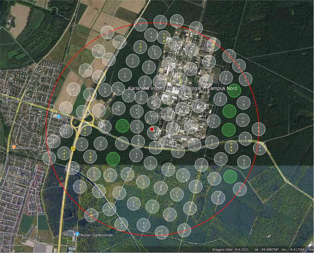
However, such an approach requires the installation of a large number of surface seismic sensors. For the DeepStor1 well, it is planned to install more than 100 autonomous sensors within a radius of ~1.5 km around the drilling zone. A planning phase is therefore necessary, leading to the selection of sensor locations based on the planned trajectory of the well and the local environmental constraints (forest, agricultural fields, roads, etc.).
The internship/thesis covers the tasks associated with this planning work, namely:
- Defining the study area
- Defining possible measurement points and integrating them into a GIS for easy and efficient location in the field;
- Carrying out a field survey to validate or, if necessary, reposition the measurement points according to actual field conditions.
- From this design, estimating the resolution of the network based on estimated noise levels and drilling speeds by forward modelling. (This part will be developed to a greater or lesser extent depending on the time available.)
The expected results will therefore be:
- A field report with the GIS project (QGIS).
- A report on the expected resolution of the network.
- An oral presentation of the results to the members of the KIT research team.

